![](/images/other/stat-length.png)
![Excursión A pie Bergisch Gladbach - O Rund um Berg.Gladbach-Herkenrath - Photo](https://media.geolcdn.com/t/1900/400/ext.pjpeg?maxdim=2&url=https%3A%2F%2Fmedia.geolcdn.com%2Ff%2F8357e86b-ec16-43aa-a2d3-3e1af5c24582.jpeg)
O Rund um Berg.Gladbach-Herkenrath
SityTrail - itinéraires balisés pédestres
Tous les sentiers balisés d’Europe PRO
![Longitud](/images/other/stat-length.png)
Longitud
7,4 km
![Altitud máxima](https://static1.geolcdn.com/siteimages/upload/files/1508320355ic_sort_altitude_max_24dp.png)
Altitud máxima
229 m
![Desnivel positivo](https://static1.geolcdn.com/siteimages/upload/files/1508320355ic_sort_den_pos_24dp.png)
Desnivel positivo
175 m
![Km-Effort](/images/other/stat-length.png)
Km-Effort
9,7 km
![Altitud mínima](https://static1.geolcdn.com/siteimages/upload/files/1508320355ic_sort_altitude_min_24dp.png)
Altitud mínima
124 m
![Desnivel negativo](https://static1.geolcdn.com/siteimages/upload/files/1508320355ic_sort_den_neg_24dp.png)
Desnivel negativo
168 m
![Boucle](https://static1.geolcdn.com/siteimages/upload/files/16400158638029165_repeat_loop_refresh_sync_direction_icon.png)
Boucle
No
Baliza
Fecha de creación :
2022-02-11 12:47:10.464
Última modificación :
2022-02-11 12:47:10.464
![A pie](https://static1.geolcdn.com/sitytour/trail-icons/100.png)
2h11
Dificultad : Fácil
![Escanee este código QR para abrir la excursión en la aplicación SityTrail](https://capi.geolives.com/qq0zvz2zws4bq2lad0pu/sitytour/trails/3087877/qr.png?size=200)
Aplicación GPS de excursión GRATIS
A propósito
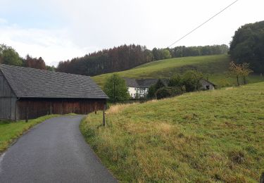
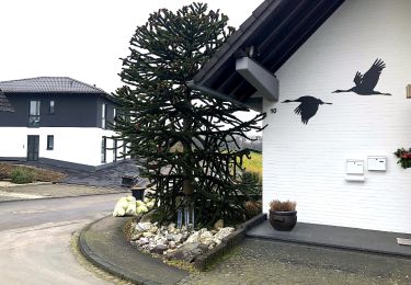
Ruta A pie de 7,4 km a descubrir en Renania del Norte-Westfalia, Rheinisch-Bergischer Kreis, Bergisch Gladbach. Esta ruta ha sido propuesta por SityTrail - itinéraires balisés pédestres.
Descripción
Trail created by Sauerländischer Gebirgsverein.
Symbol: Kreis
Localización
País:
Germany
Región :
Renania del Norte-Westfalia
Departamento/provincia :
Rheinisch-Bergischer Kreis
Municipio :
Bergisch Gladbach
Localidad:
Unknown
Salida:(Dec)
Salida:(UTM)
371031 ; 5649145 (32U) N.
Comentarios
Excursiones cerca
![Excursión A pie Bergisch Gladbach - BASt Rundweg A2 - Photo](https://media.geolcdn.com/t/375/260/ext.jpg?maxdim=2&url=https%3A%2F%2Fmedia.geolcdn.com%2Ff%2Fc81d1256-cff1-40ad-9978-d43cbbb8cc9c.jpeg)
![A pie A pie](https://static1.geolcdn.com/sitytour/trail-icons/100.png)
BASt Rundweg A2
A pie
Fácil
Bergisch Gladbach,
Renania del Norte-Westfalia,
Rheinisch-Bergischer Kreis,
Germany
![](/images/other/stat-length.png)
5,9 km | 6,9 km-effort
1h 34min
![](https://static1.geolcdn.com/siteimages/upload/files/16400158638029165_repeat_loop_refresh_sync_direction_icon.png)
No
![Excursión A pie Bergisch Gladbach - BASt Rundweg A1 - Photo](https://media.geolcdn.com/t/375/260/ext.jpg?maxdim=2&url=https%3A%2F%2Fmedia.geolcdn.com%2Ff%2F2165c68b-ab60-47c2-b853-b1f87c326248.jpeg)
![A pie A pie](https://static1.geolcdn.com/sitytour/trail-icons/100.png)
BASt Rundweg A1
A pie
Fácil
Bergisch Gladbach,
Renania del Norte-Westfalia,
Rheinisch-Bergischer Kreis,
Germany
![](/images/other/stat-length.png)
4,9 km | 5,6 km-effort
1h 16min
![](https://static1.geolcdn.com/siteimages/upload/files/16400158638029165_repeat_loop_refresh_sync_direction_icon.png)
No
![Excursión A pie Overath - Steinenbrück Rundweg A2 - Photo](https://media.geolcdn.com/t/375/260/ext.jpg?maxdim=2&url=https%3A%2F%2Fmedia.geolcdn.com%2Ff%2Ff9384976-73ea-43d1-881f-62b07725c51f.jpeg)
![A pie A pie](https://static1.geolcdn.com/sitytour/trail-icons/100.png)
Steinenbrück Rundweg A2
A pie
Fácil
Overath,
Renania del Norte-Westfalia,
Rheinisch-Bergischer Kreis,
Germany
![](/images/other/stat-length.png)
7,7 km | 10,4 km-effort
2h 21min
![](https://static1.geolcdn.com/siteimages/upload/files/16400158638029165_repeat_loop_refresh_sync_direction_icon.png)
Sí
![Excursión A pie Odenthal - Höffe Rundweg A6 - Photo](https://media.geolcdn.com/t/375/260/ext.jpg?maxdim=2&url=https%3A%2F%2Fmedia.geolcdn.com%2Ff%2F118d5a55-83f1-46a3-ad05-d231629ccb1e.jpeg)
![A pie A pie](https://static1.geolcdn.com/sitytour/trail-icons/100.png)
Höffe Rundweg A6
A pie
Fácil
Odenthal,
Renania del Norte-Westfalia,
Rheinisch-Bergischer Kreis,
Germany
![](/images/other/stat-length.png)
3,3 km | 4,8 km-effort
1h 5min
![](https://static1.geolcdn.com/siteimages/upload/files/16400158638029165_repeat_loop_refresh_sync_direction_icon.png)
Sí
![Excursión A pie Bergisch Gladbach - [U] Rundweg Asselborn - Schiff - Hombach - Photo](https://media.geolcdn.com/t/375/260/ext.jpg?maxdim=2&url=https%3A%2F%2Fmedia.geolcdn.com%2Ff%2F538de2de-e757-46d2-b801-d02da58106d2.jpeg)
![A pie A pie](https://static1.geolcdn.com/sitytour/trail-icons/100.png)
[U] Rundweg Asselborn - Schiff - Hombach
A pie
Fácil
Bergisch Gladbach,
Renania del Norte-Westfalia,
Rheinisch-Bergischer Kreis,
Germany
![](/images/other/stat-length.png)
5,2 km | 6,8 km-effort
1h 32min
![](https://static1.geolcdn.com/siteimages/upload/files/16400158638029165_repeat_loop_refresh_sync_direction_icon.png)
No
![Excursión A pie Bergisch Gladbach - Herrenstrunden Rundweg A1 - Photo](https://media.geolcdn.com/t/375/260/ext.jpg?maxdim=2&url=https%3A%2F%2Fmedia.geolcdn.com%2Ff%2F538de2de-e757-46d2-b801-d02da58106d2.jpeg)
![A pie A pie](https://static1.geolcdn.com/sitytour/trail-icons/100.png)
Herrenstrunden Rundweg A1
A pie
Fácil
Bergisch Gladbach,
Renania del Norte-Westfalia,
Rheinisch-Bergischer Kreis,
Germany
![](/images/other/stat-length.png)
3,4 km | 4,6 km-effort
1h 2min
![](https://static1.geolcdn.com/siteimages/upload/files/16400158638029165_repeat_loop_refresh_sync_direction_icon.png)
Sí
![Excursión A pie Bergisch Gladbach - Herrenstrunden Rundweg A3 - Photo](https://media.geolcdn.com/t/375/260/ext.jpg?maxdim=2&url=https%3A%2F%2Fmedia.geolcdn.com%2Ff%2F538de2de-e757-46d2-b801-d02da58106d2.jpeg)
![A pie A pie](https://static1.geolcdn.com/sitytour/trail-icons/100.png)
Herrenstrunden Rundweg A3
A pie
Fácil
Bergisch Gladbach,
Renania del Norte-Westfalia,
Rheinisch-Bergischer Kreis,
Germany
![](/images/other/stat-length.png)
4,9 km | 6,5 km-effort
1h 28min
![](https://static1.geolcdn.com/siteimages/upload/files/16400158638029165_repeat_loop_refresh_sync_direction_icon.png)
No
![Excursión A pie Bergisch Gladbach - Herrenstrunden Rundweg A2 - Photo](https://media.geolcdn.com/t/375/260/ext.jpg?maxdim=2&url=https%3A%2F%2Fmedia.geolcdn.com%2Ff%2Fb5681d97-5413-42fc-b1f7-728a89266cf4.jpeg)
![A pie A pie](https://static1.geolcdn.com/sitytour/trail-icons/100.png)
Herrenstrunden Rundweg A2
A pie
Fácil
Bergisch Gladbach,
Renania del Norte-Westfalia,
Rheinisch-Bergischer Kreis,
Germany
![](/images/other/stat-length.png)
6,6 km | 8,3 km-effort
1h 53min
![](https://static1.geolcdn.com/siteimages/upload/files/16400158638029165_repeat_loop_refresh_sync_direction_icon.png)
Sí
![Excursión A pie Odenthal - Höffe Rundweg A1 - Photo](https://media.geolcdn.com/t/375/260/ext.jpg?maxdim=2&url=https%3A%2F%2Fmedia.geolcdn.com%2Ff%2Feaed964f-6e82-4424-b080-beb0f759a0ac.jpeg)
![A pie A pie](https://static1.geolcdn.com/sitytour/trail-icons/100.png)
Höffe Rundweg A1
A pie
Fácil
Odenthal,
Renania del Norte-Westfalia,
Rheinisch-Bergischer Kreis,
Germany
![](/images/other/stat-length.png)
3,3 km | 4 km-effort
53min
![](https://static1.geolcdn.com/siteimages/upload/files/16400158638029165_repeat_loop_refresh_sync_direction_icon.png)
No